U.S. Postal Service ZIP Codes
The U.S. ZIP Code, also known as the Zone Improvement Plan code, is a postal coding system used by the United States Postal Service (USPS) to expedite and improve the efficiency of mail distribution.
The most basic format of a U.S. ZIP Code consists of five digits. An extended version, known as ZIP+4, adds an additional four digits. This structure enables postal offices to process large volumes of mail more efficiently, ensuring more accurate and faster delivery to destinations.
I. U.S. ZIP Code Format
U.S. ZIP Codes typically contain five digits. Sometimes, they are followed by a hyphen and four additional digits, forming a more detailed nine-digit ZIP Code.
The format is: ZIP Code (5 digits) + hyphen (-) + 4-digit supplemental code. Example: 12345-6789.
5-Digit ZIP Code:
First digit: Represents a broad geographic region nationwide, ranging from 0 (East) to 9 (West).
Second and third digits: Indicate a smaller geographic area, typically a state or a portion of a state.
Fourth and fifth digits: Represent an even smaller area, such as a city, town, or village.
9-Digit ZIP Code (ZIP+4): "XXXX" added after the 5-digit code.
Sixth and seventh digits: Represent a region or several blocks.
Eighth and ninth digits: Represent a segment or a side of a street.
For example, ZIP Code 90210 corresponds to an area in Beverly Hills, California, while 90210-1234 points to a specific address within that area.
Regional ZIP Code Ranges (by first digit):
Eastern U.S.: ZIP Codes starting with 0, 1, 2, 3.
Central U.S.: ZIP Codes starting with 4, 5, 6, 7.
Western U.S.: ZIP Codes starting with 8, 9.
II. U.S. State Map
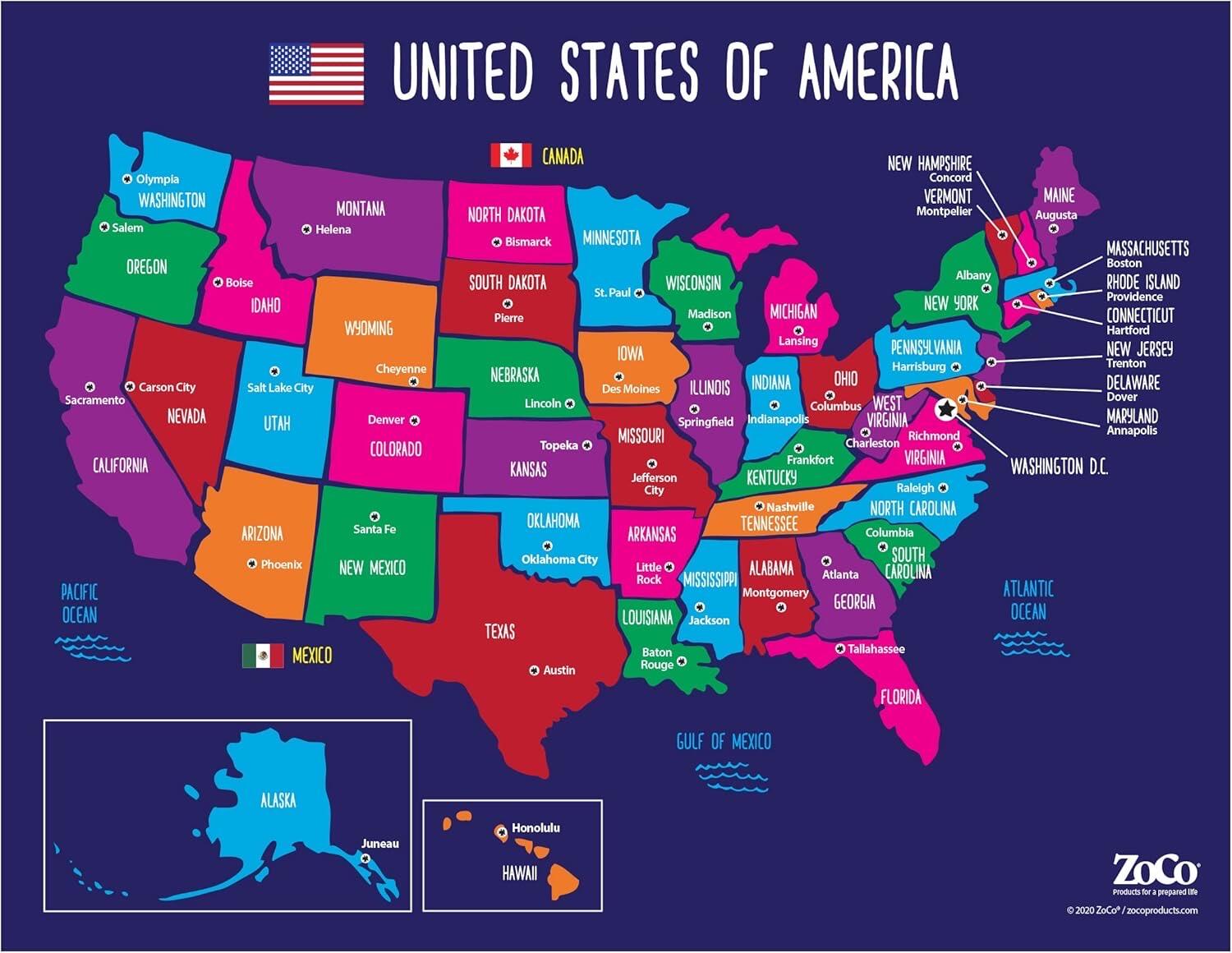
For a visual reference, here is a map of U.S. states: The United States comprises 50 states and several territories.
III. U.S. ZIP Codes
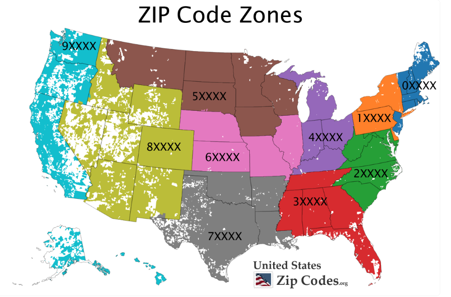
The first digit of a U.S. ZIP Code is assigned geographically, following a sequential numbering system from the northeastern United States to the western regions. This means the first digit of a ZIP Code generally represents the state or broader geographic area of the mailing address. For example, the numeral "1" typically corresponds to the northeastern United States.
Geographical Distribution of U.S. ZIP Codes
The U.S. ZIP Code system divides the mailing area into 10 regions, each corresponding to specific states or territories. As illustrated above, the associated geographical areas are as follows:
Blue and orange regions: ZIP Codes beginning with 0 and 1 correspond to the Northeastern United States.
Green and red regions: ZIP Codes beginning with 2 and 3 correspond to the Atlantic Coast region.
Purple and brown regions: ZIP Codes beginning with 4 and 5 correspond to the Southern United States.
Pink and gray regions: ZIP Codes beginning with 6 and 7 correspond to the Midwestern United States.
Light green and teal regions: ZIP Codes beginning with 8 and 9 correspond to the Western United States.
1.The Second Digit of U.S. ZIP Codes
2.The Second Digit of U.S. ZIP Codes
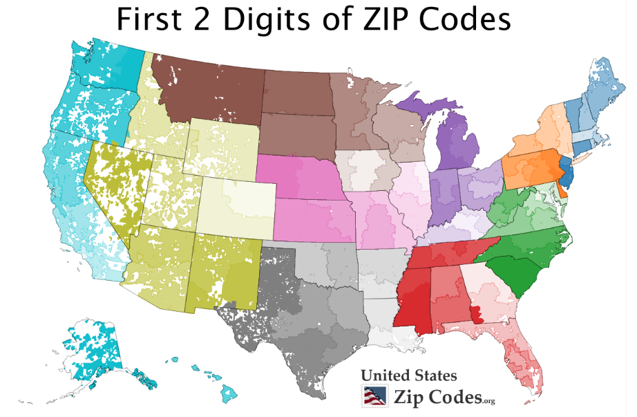
The second digit of a U.S. ZIP Code corresponds to a more specific state or sub-regional code. For example, ZIP Codes in New York State typically begin with "1", while those in California generally start with "9".
3.The Third Digit of U.S. ZIP Codes
The third digit of a U.S. ZIP Code designates a specific county or city within that region. For instance, the third digit "1" may represent Miami-Dade County in its relevant ZIP Codes.
4.The Fourth and Fifth Digits of U.S. ZIP Codes
The fourth and fifth digits further pinpoint the location by identifying a specific post office within that county or city. These digits provide a more detailed destination for mail delivery.
5.The Last Four Digits of the U.S. ZIP Code: ZIP+4 Code
The ZIP+4 code consists of the four additional digits following the basic five-digit ZIP Code. It enables more precise address location, ensuring mail reaches a specific street, building, or postal delivery point. When combined with the basic five-digit code, it forms a complete nine-digit ZIP+4 code.
Not all addresses have a unique ZIP+4 code. Many addresses still use only the basic five-digit ZIP Code; the ZIP+4 extension is typically used when a higher level of precision is required.
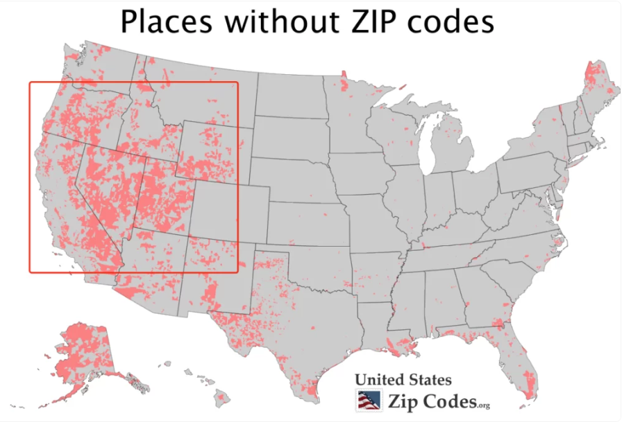
6.Some Remote Areas Do Not Have U.S. ZIP Codes
7.Special U.S. ZIP Codes
Not all ZIP Codes follow standard geographic divisions.
For example:
The U.S. Navy shares a unified ZIP Code system known as "Fleet Post Office" (FPO).
Diplomatic missions use a shared system called "Diplomatic Post Office" (DPO).
FPO and DPO codes do not represent physical locations but are used for mail delivery to U.S. Navy ships, naval bases, and overseas embassies/consulates, ensuring secure and efficient delivery.
On a geographic map, certain remote and sparsely populated areas—such as large parts of Nevada and Utah—may not have specific ZIP Codes assigned.
IV. How to Quickly Look Up a U.S. ZIP Code?
U.S. ZIP Codes vary based on precise geographic location. To determine the correct ZIP Code for a specific address, it is recommended to use the United States Postal Service (USPS) official website or other reliable online ZIP Code lookup tools to ensure accuracy.